Posts Tagged ‘Hingoli’
Sizing up rural and urban settlements in Maharashtra
 The districts of Jalna, Osmanabad, Hingoli, Satara, Ratnagiri, Washim, Nandurbar, Gondiya, Gadchiroli and Sindhudurg in Maharashtra all enjoy a rural built-up to urban built-up ratio of more than 2 (where the built-up area of the district’s rural settlements are at least twice the area of its urban settlements).
In the chart, the light green bars show a district’s rural built-up area, the light maroon its urban built-up area. The number associated with the name of the district is the ratio between the two kinds of built-up area.
Such a comparison helps us understand the dependency of the two kinds of populations in a district, rural and urban, upon the natural resources (as classified by land types). The chart shows us that some districts (see Jalgaon, Sholapur, Satara and Ratnagiri) have total rural built-up areas of 150 square kilometres and above. But whereas the urban built-up areas of Jalgaon and Sholapur are more than 100 sq km each this is not so for the other two districts.
Districts may have similar ratios between rural and urban built-up areas – see Ahmednagar, Akola and Dhule – but whereas the built-up areas of both types are more than 100 sq km in Ahmednagar they are smaller in the other two districts. There are only three districts for which the total rural built-up area is less than 50 sq km: Parbhani, Hingoli ad Washim.
There are 15 districts in which there is at least 1.5 sq km of rural built-up area for 1 sq km of urban built-up and this indicates that in these districts the base of agricultural and allied activities is still strong and therefore needs continuous encouragement. There are 7 districts for which this ratio is between 1.5 and 1 and these therefore must be watched for signs of quickening urbanisation which will need to be curbed in the interests of sustainability and indeed of the provision of food.
I have taken the data from the land use and land change information for 2011-12 collected by the Resourcesat-2 satellite with land classification and calculation carried out by the National Remote Sensing Centre (NRSC), Indian Space Research Organisation (ISRO), Department of Space, under the Natural Resources Census Project of the National Natural Resources Repository Programme. It is available through Bhuvan, the geo-platform of ISRO.
Urban areas are non-linear built-up areas covered by impervious structures adjacent to or connected by streets. This class includes residential areas, mixed built-up, recreational places, public and private utilities, communications, commercial areas, reclaimed areas, vegetated areas within urban zones, transportation infrastructure, industrial areas and their dumps, and ash/cooling ponds. Rural built-up areas are the lands used for human settlement in which the majority of the population is involved in agriculture. These are built-up areas, small in size, mainly associated with agriculture and allied sectors and non-commercial activities. They can be seen in clusters both non-contiguous and scattered.
The last 4 districts – Nagpur, Nashik, Thane and Pune – have their urban built-up bars coloured differently to indicate that their scales are beyond, and very much above, the 150 sq km of the chart. Mumbai city and suburban is omitted entirely.
How a district employs land and crop

A plotting of the cropland size categories with the number of holdings for the district of Hingoli in Maharashtra. The central group of rectangles displays the distribution, relative to each other, of the size categories of holdings (in hectares, ha.). The blue squares, also relative to each other, displays the number of holdings for each farm size category. The data source is the Agricultural Census 2010-11.
In the district of Hingoli, Maharashtra, the allocation of cultivated land between food crops and non-food crops is somewhat in favour of non-food crops. That is, for every hectare planted with a food crop 1.3 hectares is planted with a non-food crop. The broad categories we have under food crops are: cereals, pulses, vegetables and fruit. Under non-food crops there are: oilseeds, sugarcane, fibres, spices and fodder.

Where Hingoli district is in Maharashtra state.
The Agricultural Census 2010-11 detailed data for Hingoli shows that at the time of the survey 493,927 hectares were under cultivation for all kinds of crops, both food and non-food. As this is a count of how much land was under cultivation by crop, the total land under cultivation for all crops taken together is more than the total land under cultivation when measured according to land use. This is so because of crop rotation during the same agricultural year, inter-cropping and mixed cropping – for a plot, the same land may raise two kinds of crops in a year.
Size categories of farm holdings, with number of holdings and total area under each category for Hingoli district, Maharashtra.
The 493,927 hectares under cultivation in Hingoli are divided under 213,286 hectares for food crops and 280,640 hectares under non-food crops. This gives us the overall picture that the farming households of Hingoli choose to give more land for crop types under the ‘non-food’ category. As the settlement pattern of Hingoli is very largely rural – that means, few towns and these are the district headquarters and two more taluka centres – do the farming households of Hingoli grow enough to feed themselves comfortably? Do the farming households have the labour needed to continue cultivating so that they can feed themselves and their village communities? How are choices relating to land use and crop made?
Using the publicly available information from a variety of government sources, we are able to find parts of answers. The Agricultural Census 2010-11 is one such source, the Census of India 2011 is another, so are the tables provided by the Department of Economics and Statistics of the Ministry of Agriculture. The graphical representation I have prepared here helps provide the land use basis upon which to layer the district information from other sources.
Between Berar and Nizam, a taluka in Maharashtra

This is a small taluka in Vidarbha, Maharashtra. To the north, not far away, and visible on the horizon, is the line of hills called the Sahyadriparbat, which is also called the Ajanta range after the site with the remarkable frescoes.
Also due north is the city of Akola, and a little farther away north-east is Amravati, named after Amba whose ancient temple the old city, with more than 900 years of recorded history, is built around. To the west, in a nearly direct line west, is Aurangabad. To the south had stretched, not all that long ago, the dominions of the Nizam of Hyderabad, to which this little taluka had once belonged.
 Sengaon is the name of this taluka (an administrative unit unimaginatively called a ‘block’ by the administrative services, elsewhere a tehsil or a mandal) and today it is one of five talukas of the district of Hingoli, which itself is only very recent, for before 1999 it was a part of the district of Parbhani. But Hingoli town is an old one – its cantonment (old bungalows, large compounds) was where the defenders of this part of the Nizam’s northern dominions resided (over the frontier had been Berar), and there was a large and thriving market yard here, as much for the cotton as for the jowar.
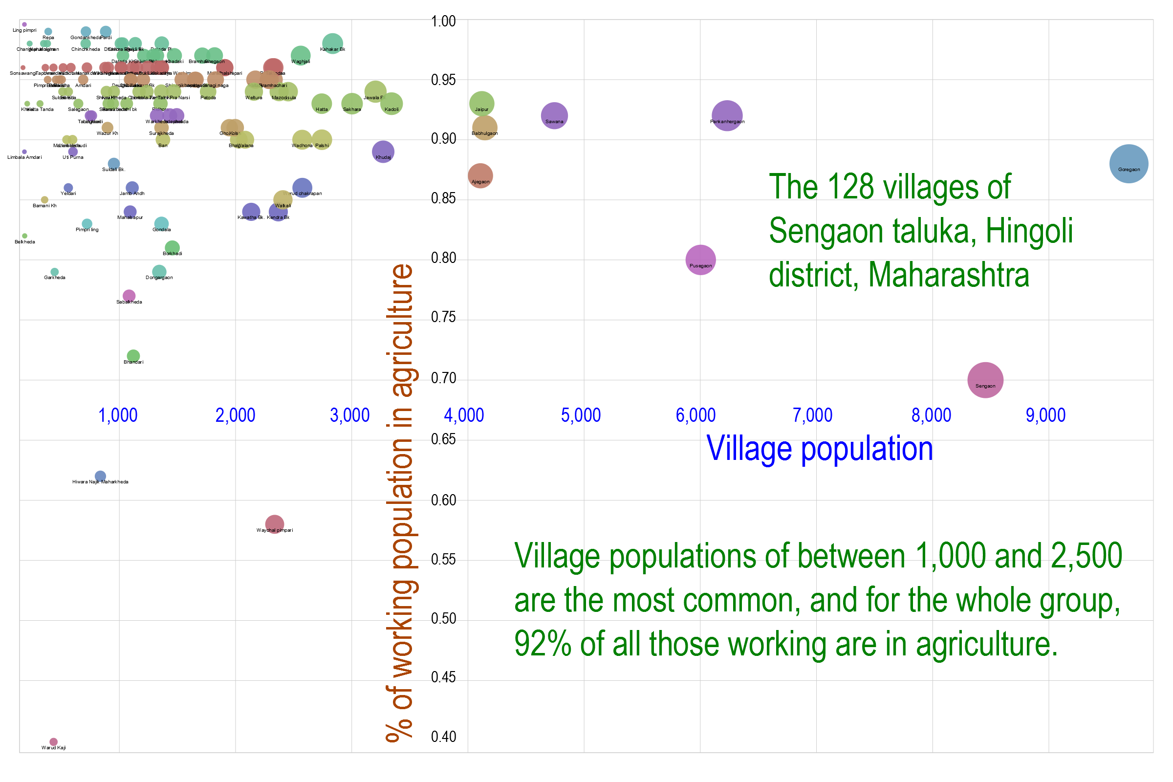
The villages of Sengaon are mostly small and agricultural, which is how the entire district was described in the district gazetteer of the 1960s. There are today 128 inhabited villages in this little taluka, and this chart (click it for a full size version, data from Census 2011) shows how their populations depend almost entirely on agriculture – for the group of villages, 92% of all those working do so in the fields, whether their village is as small as Borkhadi or Hudi, or as large as Sakhara or Palshi.
There were Bhois here (and still are), the fishermen and one-time litter-bearers, there are ‘deshastha‘ Maratha Brahmins, there are ‘Karhada‘ who take their name from Karhad, the sacred junction of the Koyna and the Krishna in Satara district, there are the former leather-workers and rope-makers called the ‘Kambhar‘, there are the weavers who are the ‘Devang‘ (with their four sub-divisions, and themselves a division of the great Dhangars or shepherds), there are the ‘Virasaiva‘ or the ‘Shivabhakta‘ or the ‘Shivachar‘ (all Lingayats) who have for generations been traders and agriculturists.
 There are the ‘Pata Jangam‘ still who must lead a celibate life and could be distinguished by the long loose roseate shirts they wore and who spent their days in meditation and prayer, there were the ‘Mali‘ the fruit and vegetable growers the gardeners and cultivators (and in times past their society was divided according to what they grew so the ‘phool Mali‘ for flower the ‘jire Mali‘ for cumin seed and the ‘halade Mali‘ for turmeric), and there are the Maratha – the chief warriors, land owners and cultivators – and the 96 families to which they belong, there are Maheshvari Marwaris, the ‘suryavanshi‘ or ‘chandravanshi‘ Rajputs, the Lambadi who at one time were grain and* salt carriers but also cattle breeders and graziers, and the ‘Vadar‘ or stone and earth workers.
This is who they are and were in the taluka of Sengaon, beyond and away from the dry and terse descriptions contained on government beneficiaries lists and drought relief programmes. They know well their trees in the expansive grasslands of the north Deccan – the Indian bael, the ‘daura‘ or ‘dhamora‘ tree, the ‘saalayi‘ whose bark and gum resin treats all sorts of ailments, the ‘madhuca‘ or mahua, the amalaki – and do their best to protect them; the twigs and sticks that fuel their ‘chulhas’ are those which fall to the earth.
It is a small taluka but old, like the others in the ancient north Deccan, and in Marathi, some of the elders of the villages here explain, with great embellishment and pomp, how the Brihat Samhita contains detailed instructions of what to plant on the embankments of a water tank, especially the madhuca, which they will add could be found in villages whose names they all know well: Pardi, Shivni, Karegaon, Barda, Sawarkheda, Suldali, Kawardadi, Datada, Jamthi, Sabalkheda …
